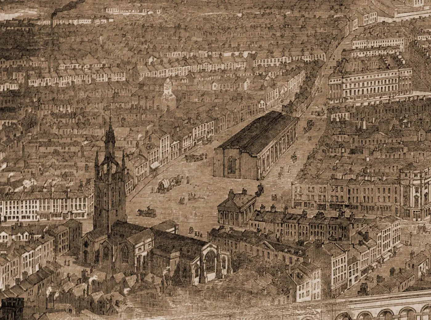
Lost Buildings of Newcastle: What Stood Where
A Georgian shopping arcade under a roundabout, two-thirds of a Dobson square under a shopping centre, a panopticon prison under an office block. Twelve buildings Newcastle no longer has, and the exact spot to stand to see where each one was.
Newcastle is unusually good at losing buildings. The city centre you walk through is largely the product of two demolition waves, the 1830s clearance that made room for Richard Grainger's new streets and the post-war road and shopping schemes of the 1960s and 70s, and both took things that would be untouchable today. What follows is a guide to twelve of them, arranged so that each entry ends somewhere you can actually stand. Where the sources disagree, and on this subject they disagree often, we have said so rather than picked a side.
The Royal Arcade, Pilgrim Street
Conceived in the 1820s as a corn exchange and switched to a shopping arcade before building began, the Royal Arcade was John Dobson's design for the builder-developer Richard Grainger: Greek Revival, ashlar, Doric columns at ground level with Corinthian above, and a cost of £40,000. Accounts of the build date vary slightly, from 1830 to 1832 in some sources and from June 1831 to May 1832 in others. The arcade itself ran 250 feet under a vaulted ceiling and a line of huge domed skylights, with eight large shops on each side and a black and white chequered floor, modelled on the Lowther Arcade in London. In December 1960 John Betjeman publicly called it the finest Georgian shopping arcade in the country, and noted that it had been threatened with destruction.
It was demolished in 1963 for the Central Motorway East, the Pilgrim Street roundabout and Swan House. Newcastle University's Special Collections records the detail that makes the loss worse than a straightforward demolition: the facade was taken down brick by brick across 1963 and 1964, and the plan to rebuild it next to Swan House never happened. What became of the numbered stones is not recorded anywhere we could find.
The arcade also holds one of the city's darkest Victorian stories. On 6 December 1838, a clerk named Joseph Millie was beaten to death in the Newcastle upon Tyne Savings Bank offices inside the arcade. A bent and bloodied poker was found, and the bank's actuary, Archibald Bolam, set fire to the offices to conceal it. Tried at Newcastle Assizes before Mr Baron Maule, he was convicted of manslaughter, not murder as is sometimes written, and transported to Tasmania.
A full-size replica of the arcade was later built at the pedestrian level beneath Swan House, in concrete and fibrous plaster rather than stone, and here the record genuinely breaks down. The council's own historic environment record says it was reconstructed in 1970 and that, as of 2004, it formed part of a bar in the converted building. Press accounts say the plaster replica went up in 1969 and was itself demolished in 2002 or 2003 to make way for a bar and restaurant. One says the replica became the bar; the other says it was destroyed for it. Since then one of the roundabout underpasses has been closed off and filled in. This is the most interesting unanswered question in the guide, and it is answerable on foot.
Best for: Standing at the pedestrian level inside the Pilgrim Street roundabout, under 55 Degrees North, and working out for yourself what is left.
Old Eldon Square
The square is usually described as having lost three sides. It lost two. The north and west terraces came down in the early 1970s for the Eldon Square Shopping Centre, which opened in 1976, and the east terrace is still standing, listed at Grade II* under list entry 1355254. That matters for anyone going to look, because a third of the Georgian square is still in front of you.
It was designed by John Dobson to Grecian designs of 1824 and built between 1825 and 1831 for Richard Grainger, with Thomas Oliver co-credited in the statutory listing. The surviving range gives the measure of what went: sandstone ashlar under a Welsh slate roof, a basement and three storeys with some later attics, thirty-three bays in all, and slightly projecting five-bay end pavilions defined by giant pilasters. Multiply that across three sides and you have Newcastle's first formal residential square, the piece of Dobson and Grainger townscape that came closest to answering Bath or the Edinburgh New Town. Its demolition was contentious nationally and is still cited as a landmark conservation defeat.
One correction worth making, because half the local internet gets it wrong. The memorial in Old Eldon Square is the Newcastle and District War Memorial of 1923, Grade II*, list entry 1115605, with a bronze St George on a rearing charger by the sculptor Charles Hartwell, unveiled by Earl Haig on 26 September 1923. The South African War Memorial, by Thomas Eyre Macklin and dated 1907, is a different listed monument in a different place, at Percy Street and the Haymarket, with a winged Victory on a tall tapered column. They are a two-minute walk apart and they are constantly merged.
Best for: Seeing the surviving east terrace and understanding, in one glance, the scale of what the shopping centre replaced.
The Town Hall, St Nicholas Square
Newcastle's Victorian town hall stood immediately north of the cathedral, on St Nicholas Square and the Cloth Market. The site is now Stanegate House, with the southern part of the redevelopment given over to No. 1 Cathedral Square.
When it was built, and by whom, is a real and unresolved conflict. Wikipedia gives a single Italian neoclassical building of 1863 by John Johnstone. The council's own historic environment record gives something quite different: a corn exchange designed by John Green, built on the site of Middle Street and opened on 30 October 1839, with the town hall erected above it by Johnston in 1858. Those two accounts cannot both be right, and we are not going to pretend otherwise. What is agreed is that the building held a corn exchange converted into an assembly hall seating 3,000, that a Gray and Davison organ was ordered in 1858 and opened in 1862, and that it served as the seat of city government until the Civic Centre took over in November 1968.
It was demolished in 1973 for commercial redevelopment, five years after it had stopped being needed. Nothing of it is established as surviving. There is an architectural fragment recorded in St Nicholas Square, but it is medieval, from the destroyed tower of Newcastle Cathedral, and has nothing to do with the town hall.
Best for: Standing on the cathedral's north side and looking at a 1970s office block where the council used to meet.
Anderson Place
The grandest private house in the city stood where the top of Grey Street and Market Street now run. Built as Newe House in the late sixteenth century by the merchant Robert Anderson, reusing the precinct of the dissolved Franciscan friary at Greyfriars, it was later known as Anderson Place and as Newcastle House. It is often said to have been the largest house in the country standing inside a city wall, though that claim circulates with "it is said" attached and we could not trace it to any authority. No source we read named an architect, including Mackenzie's 1827 account, which was written while the house still stood.
Its strongest fact is a royal one. Charles I was held at Anderson Place through the winter of 1646 and 1647, after his surrender to the Scots and before he was handed over to the English Parliament.
The house and its grounds were cleared in the 1830s for Richard Grainger's new town, and that single transaction is why Grainger Town exists in the shape it does: it released a large private estate in the middle of the city all at once, rather than in parcels. Who bought it in 1834 is contested, with some accounts giving Newcastle Corporation and others Grainger himself. Nothing of the house is established as surviving, and we would rather say that plainly than fill the gap.
Best for: Walking the top of Grey Street towards Grainger Market and picturing a Tudor mansion and its gardens across the whole block.
The Turk's Head, Bigg Market
There is a Turk's Head on Grey Street and it is not a lost building. It stands, listed at Grade II* under entry 1329950, and trades today as offices at No. 71 Grey Street, the eight-bay classical block opposite the Theatre Royal with the giant order and the carriage entrance in the right-hand end bay. The lost Turk's Head is the earlier one, in the Bigg Market.
That house was built in 1744 by William Parker, and its Long Room opened in 1747. No architect is recorded and Parker appears as builder and proprietor. The Long Room is the reason it belongs in this guide. From 1747 it was used as a theatre by a York company of players under a manager named Baker, and it served as one for about forty years, known simply as the Theatre in the Bigg Market. The link to what came next is direct: Austin and Whitlock, the first managers of the Theatre Royal when it opened in 1788, had previously run the Turk's Head theatre. Mackenzie in 1827 called it a very commodious, well-conducted house with the largest public room in the town attached to it. Its cock-pit was, in the council record's words, its great attraction, with mains advertised in the Newcastle Courant in April 1798 and March 1814.
It was demolished to make way for Grainger Street. No year is recorded. The historic environment record simply notes that the site is now occupied by the street itself, and that the house stood nearly opposite the Fighting Cocks inn. Nothing structural survives and no relic is catalogued. What survives is the name: after the demolition a new Turk's Head was built on Grey Street, and the council still titles that record the New Turk's Head Hotel, which is contemporary evidence that people at the time understood the second building as the first one's successor.
Two footnotes on the surviving Grey Street building, since readers will ask. It was a Women's Social and Political Union meeting place, and suffragettes celebrated Kathleen Brown's release from Holloway there on 19 July 1909; a heritage plaque went up on 8 March 2017. And the persistent claim that the Beatles wrote "She Loves You" in a room there is not settled: the city abandoned a commemorative plaque in 2003 when the surviving Beatles could not say whether it had been the Turk's Head or the Imperial Hotel in Jesmond, and contemporary reporting at the time favoured the Imperial.
Best for: Standing at the Bigg Market end of Grainger Street, on top of a Georgian inn that was a theatre for forty years.
The First Theatre Royal, Mosley Street
Newcastle's first Theatre Royal opened on 21 January 1788 with the comedy The Way to Keep Him and The Sultan. The architect was David Stephenson, who also built All Saints Church on Pilgrim Street, and the cost came to £6,281 17s 6d including the land, the Act of Parliament and building expenses to April 1789. Mackenzie says the royal licence came by an Act obtained in 1787; the present theatre's own account instead dates the patent to a public meeting in 1784. Mackenzie was writing locally and closer to the event, but both versions are in circulation.
Mackenzie put the building in the middle of Mosley Street, 120 feet long and 54 feet broad, with a capacity of 1,350: 800 in the gallery, 200 in the pit and 350 in the boxes, behind a covered porch adorned with festoons and dramatic emblems. Stephen Kemble managed it from 1791 to 1806. On 19 February 1823, during a performance of the farce Tom and Jerry, a gas light in one of the boxes set fire to the woodwork enclosing the pipe. The fire was put out quickly, but cries of "fire" caused a rush for the doors and several playgoers were crushed to death. Accounts differ on how many, and Mackenzie, writing four years later in the same town, does not mention it at all.
The theatre came down in 1836 because it stood on the line of Grey Street and blocked Grainger's scheme. Objections were raised on exactly that ground, and Grainger was contractually committed to building a replacement. The last production was on 26 June 1836, with demolition under way by November. A demolition date of 1834 also circulates and is contradicted by that final performance.
The survival is the best in the guide, and you can walk it in a minute. The council's record states that the 1788 theatre was built across the eastern end of Drury Lane, creating the dog-leg in the lane. That kink is the theatre's footprint, still legible in the street plan. No source names any standing building as occupying the site itself, so do not believe anyone who tells you which one it is.
The replacement is the Theatre Royal on Grey Street, opened on 20 February 1837 with The Merchant of Venice, and now Grade I listed under entry 1145840. It is also, incidentally, the best example in the city of a lost interior behind a surviving front. Its 1837 auditorium by Benjamin Green was destroyed by fire on the morning of 24 November 1899, after a run of Macbeth, and it reopened on 31 December 1901 with a French Renaissance auditorium by Frank Matcham. The 1901-dated balcony and the art nouveau "UPPER CIRCLE" grille are the visible scars of that fire on an otherwise Georgian front.
Best for: Walking the dog-leg at the eastern end of Drury Lane, which exists because a Georgian theatre was built across it.
The Town Wall Gates
The medieval town wall was begun in the late thirteenth century, ran roughly two miles, stood about twenty-five feet high, and had six main gates and seventeen towers. Long stretches of wall survive. Not one of the six principal gates does, and their demolition dates are individually recorded, which is unusual and useful: Close Gate in 1797, Sandgate in 1798, Pilgrim Street Gate in 1802, Westgate in 1811 or 1812, and Newgate in 1823.
They did not come down in a war or a single scheme. They came down because of traffic. Each gate was a bottleneck for wheeled vehicles, and they were removed piecemeal across a generation of street improvement. The best single fact here is that Newgate served as the town gaol from 1399 to 1822, and was pulled down the year after it was superseded, which leads directly into the next entry.
What survives is the richest walkable material in the city's heritage. There are substantial wall stretches along Bath Lane and the West Walls, plus named towers: Heber, Durham, Ever and Morden on the west side, Plummer Tower on Croft Street, Sallyport Tower at Wall Knoll and the Corner Tower. Morden Tower has a second life as a poetry venue with a reputation well beyond archaeology. The surviving wall and towers are protected, though the coverage is spread across several separate entries rather than one, so check the specific designation for whichever stretch you are looking at.
Best for: Following the West Walls from Bath Lane past Heber and Morden towers, the one stretch where the medieval town is still legible at full height.
The Medieval Tyne Bridge
Four bridges have carried that crossing. A Roman bridge, Pons Aelius, gave the fort beside Newcastle Castle its name. The medieval Tyne Bridge, rebuilt from the 1270s, carried houses, shops and a chapel on its deck, along with a gaol and the boundary between Newcastle and the Palatinate of Durham. It was destroyed in the Great Flood of 17 November 1771. Mylne's stone bridge replaced it and opened in 1781, and that in turn gave way to the Swing Bridge in 1876, built by Armstrong so that ships could pass upriver to his Elswick works. The famous green arch of 1928 is a different crossing line entirely, which is why the low-level bridge swings and the high-level one does not.
This entry produced the best survival of the lot, and it is genuinely there to be seen. One complete land arch of the medieval bridge survives under the Swing Bridge, forty-four feet wide with a twenty-one foot span, and the east face of a second may exist in the basement of Watergate Buildings. The Blue Stone, the marker of the old Newcastle and Durham boundary on the medieval deck, also survives. We have deliberately not given a listing grade for the medieval remains, because the designation recorded on that site may attach to the Swing Bridge above rather than to the arch below.
Best for: Looking underneath the Swing Bridge for a medieval arch that has been quietly holding up the Tyne crossing for seven hundred years.
Newcastle Gaol, Carliol Square
John Dobson's prison was a reformist building that failed on the day it opened. The foundation stone was laid on 4 June 1823 by Mayor Robert Bell, who placed a glass vase in a cavity in the stone containing coins struck in the reign of George IV. It opened in February 1828 after nearly five years, cost £35,000, and was built of stone from Church Quarry on Gateshead Fell.
It looked like a fortress: Gothic Revival in ashlar, with a tall entrance tower and gates on the west side of Carliol Square and boundary walls twenty-five feet high. Dobson planned a panopticon, six radiating wings leading to an elliptical building at the centre, each wing with its own exercise yard, sick room and water closet, separate wings for women and for debtors, and over a hundred cells arranged so that each looked onto the blank wall of another wing. Contemporaries called it a great and beneficent revolution in prison architecture.
Then cost forced the omission of one wing. Only five of the six were built, and the prison operated at capacity almost immediately after opening. Within ten years it was being condemned as damp, rat-infested and overcrowded. By 1856 it held twice as many prisoners as it had been designed for, and by 1890 about three times. Fifteen men and one woman were hanged there between 1829 and 1919. John William Anderson, in December 1875, was the first to be executed inside the walls; the last were Ambrose Quinn and Ernest Bernard Scott in November 1919.
It closed on 31 March 1925 and was demolished immediately afterwards, not because of fire, war or a road scheme but because the Home Office was closing prisons as committals fell nationally after 1914. A newspaper at the time called the gaol an anachronism. The site is now Telephone House, a large brick office block filling most of the eastern half of the square.
The survivals are the best documented in this guide. Some of the stone from the walls is recorded as having gone into the foundations of the Tyne Bridge, then under construction, which fits: the gaol came down in 1925 and the bridge opened in 1928. The good stone is said to have gone into the Church of St James and St Basil in Fenham, built from the winter of 1927 and consecrated in June 1931 to a design by Edward Eric Lofting, though the church's own history carefully adds that the building is faced with stone quarried at nearby Kenton, so anyone going to look at visible prison stone will mostly be looking at Kenton facing. As for the executed, the Home Office required reinterment on closure but only twelve of the fifteen bodies were recovered, and they were reburied in unmarked graves at All Saints Cemetery in Jesmond in October 1925, the location kept deliberately secret. A commemorative plaque naming them went up at the cemetery entrance on 24 November 2021.
Best for: The small grassed area in Carliol Square, believed to be the prison burial ground, with Telephone House standing over the cell blocks.
The Old Infirmary, Forth Banks
Newcastle's first hospital began with an anonymous letter to the Newcastle Courant in 1751, signed "B.K." and probably written by the surgeon Richard Lambert. A temporary infirmary opened in a house on Gallowgate on 23 May 1751, Newcastle Common Council gave land the same year, and the architect Daniel Garrett was engaged. Joseph Butler, Bishop of Durham, laid the foundation stone on 5 September 1751. The infirmary opened on 8 October 1753 at a cost of £3,697, with ninety beds, and treated 167 inpatients and 178 outpatients in its first year.
It grew in phases across the next century and a half, including a north-south wing added by John Dobson between 1852 and 1855 and the Ravensworth wing on the south front in 1885, by which point it had 270 beds. It also has a genuine claim on medical history: George Beatson, appointed senior house surgeon in 1874, introduced Lister's carbolic acid method, and a report on the state of the infirmary for 1875 recorded that there had not been a single case of sepsis during the year.
The location is what killed it. The hospital stood first in open ground and was finally surrounded by the railway and the livestock markets. It closed in 1906, the Royal Victoria Infirmary having been opened by Edward VII on 11 July that year, with patients, staff and equipment moved from Forth Banks on 15 September. The main building then stood derelict for nearly half a century before being demolished in 1954.
Nothing of the building stands above ground, but it is wrong to say nothing survives. The infirmary's burial ground, where the last burial was in 1845, was excavated in 1996 ahead of the construction of the Life Science Centre. The dig recovered forty-three articulated burials along with a great deal of disarticulated bone, many bodies wrapped in shrouds or blankets held together with pins, two well-preserved coffins in waterlogged ground, and evidence of anatomical practice on cadavers.
Best for: Standing in Times Square at the top of Forth Banks, on the ground that held a Georgian hospital and its graveyard.
The Paramount, Pilgrim Street
The Paramount Theatre opened on Monday 7 September 1931 to designs by Verity and Beverley, and was renamed the Odeon on 22 April 1940. It was an American-style super-cinema with a Wurlitzer organ, an orchestra and Tiller Girls, presenting a blank brick face to Pilgrim Street relieved by huge pilasters, brick panels and a decorative stone cornice. Inside it was Modern Baroque in blues, buffs and deep rose, with sixteen large terracotta silk panels some thirty-five feet high, a stage thirty feet deep and fifty-four wide, pilasters that flowered into glass light fittings, and over five hundred motifs and paintings. The Wurlitzer was a three-manual, nineteen-rank instrument weighing fifteen tons, mounted on a lift to the left of the stage and played by Vincent Trippett. The opening bill was a stage show called The Ladder of Roses and the film Monte Carlo with Jack Buchanan and Jeanette MacDonald.
Live performances stopped in 1936 and Paramount sold its British houses to Odeon in 1939. The building was tripled in 1975 and a fourth screen added in the former stage area in 1980. It was listed at Grade II in 1999, described as the best surviving Paramount cinema in Britain, with a well composed facade and a rich interior with Lalique glass fittings. In 2001 Odeon Theatres Ltd successfully applied to have it de-listed, which is the real story here and should not be collapsed into a simpler one.
It closed on 26 November 2002, the last films being Harry Potter and the Chamber of Secrets and Die Another Day, and the operator moved to a multiplex at The Gate. The building then stood empty for roughly fourteen years. During demolition, at eleven o'clock at night on 3 April 2017, the entire front collapsed into the street. Nobody was hurt, and the work finished the following month. The ground carried the Stack container village until it closed on 2 May 2022, and the site is now inside the Pilgrim Street regeneration.
Best for: Standing on Pilgrim Street with Worswick Street behind you, where one of Britain's best 1930s cinema interiors was de-listed and then removed.
The Cattle Market, Marlborough Crescent
Sheep and cattle markets were first held on Marlborough Crescent on 27 July 1830, every Tuesday, on ground outside the medieval walls, and they were opened explicitly to compete with Morpeth Mart, where Newcastle butchers had previously bought their livestock. The arrival of Central Station in 1850 strengthened the trade further. Livestock were driven through the streets to reach it, and the market declined through the 1960s. No source gives a last sale or a closing date, so we are not printing one.
Most of the open market ground is under the Centre for Life, which opened on 27 May 2000. But one building from it survives, and it is the most rewarding place in this guide to go and stand. John Dobson's Market Keeper's Office and Toll House is still there, in Times Square, the interior courtyard of the science centre: sandstone ashlar under a Welsh slate roof, symmetrical with bowed end projections, two storeys and three bays, with tripartite first-floor windows and a central clock turret under a low-pitched hipped roof. It is Grade II listed, list entry 1355279, first listed on 17 December 1971. Its date is usually given as around 1842, though earlier dates circulate. When the area was cleared in the 1990s the keeper's house was retained and refurbished rather than demolished.
The same ground lost something else worth remembering. Marlborough Crescent bus station, built in the late 1920s, was one of Newcastle's principal bus stations for around sixty years, serving North West Durham, Cumberland, Westmorland and the Tyne Valley through to Carlisle.
Best for: The Market Keeper's House in Times Square, a Dobson toll house left standing in the courtyard of a science centre.
Carliol House: neither lost nor saved
One building on this list is in a category of its own, and it makes the best footnote in the guide. Carliol House, on the corner of Market Street and Pilgrim Street, was built for the North Eastern Electric Supply Company in the 1920s: Portland stone with granite and a Frosterley marble doorcase, seven storeys, twenty-eight bays with a three-bay rounded corner, adapted Greek Doric columns flanking the entrance, a lead corner turret, and a bronze plaque to Sir Joseph Wilson Swan, inventor of the incandescent lamp. It had electric lifts, electric heating and a central vacuum cleaning plant, which in 1927 was the point.
It is still Grade II listed under entry 1087029, and it is also, in every meaningful sense, gone. The interior structure and the steel frame were removed floor by floor with remote-controlled excavators, and the structure was then separated from its front, leaving a retained listed facade of 130 metres and 3,150 square metres, one of the longest and highest retention schemes in the country. It won Best Project of the Year at the World Demolition Awards in 2024. Pilgrim's Quarter is rising behind it.
So it is neither accurate to say Carliol House was demolished nor that it survives. It is a listed wall with a new building behind it, which is its own kind of loss and a fair summary of how the city has handled the last century of its architecture.
A walk that takes in the survivals
If you want to do this on foot in an afternoon, the order that works is roughly north to south. Start at Old Eldon Square with the surviving east terrace and the 1923 memorial, cut through to Drury Lane for the dog-leg, then down Grey Street past the Theatre Royal and the old Turk's Head at No. 71. Carry on to Carliol Square for the gaol's grassed burial ground, then to the Pilgrim Street roundabout for the Royal Arcade's site and the unresolved question of the replica. From there head down to the Quayside, look under the Swing Bridge for the medieval arch, then walk west along the river and up to Times Square for Dobson's Market Keeper's House and the ground of the Old Infirmary. Finish on the West Walls at Bath Lane, which is the one place where the medieval town is still standing at something near its full height.
Know something about any of these buildings that we have missed, or can settle the question of the Royal Arcade replica? Get in touch and tell us.
Local businesses mentioned
Newcastle Cathedral
Cathedral Church of St Nicholas, St Nicholas Square, Newcastle upon Tyne, NE1 1PF
Grainger Market
Grainger Market, Grainger Street, Newcastle upon Tyne, NE1 5QQ
All Saints Church
All Saints Church, Akenside Hill, Newcastle upon Tyne, NE1 3UF
Theatre Royal Newcastle
100 Grey Street, Newcastle upon Tyne, NE1 6BR
Newcastle Castle
The Black Gate, Castle Garth, Newcastle upon Tyne, NE1 1RQ
Life Science Centre
Times Square, Newcastle upon Tyne, NE1 4EP
Never miss what’s on
Join the weekly Newcastlecity.live digest — the best events, news and local tips, straight to your inbox. Free, one email a week.
What's On
Scummy Mummies: Hot Mess, Northern Stage
7:30 PM · Northern Stage, Barras Bridge, Newcastle, NE1 7RH
Saria Callas at Northern Stage
7:45 PM · Northern Stage, Barras Bridge, Newcastle, NE1 7RH
The Annie Keating Band + The Dreaming Spires
7:00 PM · The Cumberland Arms, James Place Street, Ouseburn, Newcastle upon Tyne, NE6 1LD